
八王子市 topographic map
Interactive map
Click on the map to display elevation.
About this map
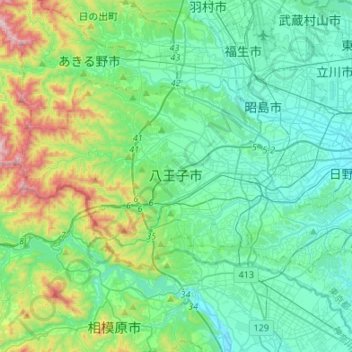
Name: 八王子市 topographic map, elevation, terrain.
Location: 八王子市, 東京都, 日本 (35.59832 139.16160 35.71912 139.43030)
Average elevation: 238 m
Minimum elevation: 54 m
Maximum elevation: 927 m
八王子市は東京都の島嶼部を除く地域の南西部、東京都心から約40キロメートルに位置している。多摩丘陵にあり、河川浸食による開析が著しく、谷が樹枝状に分布する複雑な地形となっている。下恩方町、裏高尾町、上川町、美山町などに土砂災害特別警戒区域が約900か所ある。
Other topographic maps
Click on a map to view its topography, its elevation and its terrain.