
尾道市 topographic map
Interactive map
Click on the map to display elevation.
About this map
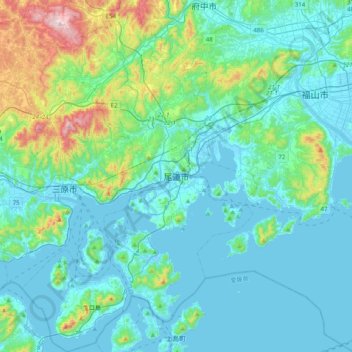
Name: 尾道市 topographic map, elevation, terrain.
Location: 尾道市, 広島県, 日本 (34.24436 133.03010 34.57310 133.29699)
Average elevation: 108 m
Minimum elevation: -2 m
Maximum elevation: 682 m
因島地区は西南部の土生港を中心とし、そこから国道317号を幹線として西北部へ向けて市街地が広がっている。重井、三庄、中庄といった地区にもまとまった住宅地がある。東部は海岸沿いに崖が連続する地形で、合間にある平坦地にいくつかの集落が点在している。
Other topographic maps
Click on a map to view its topography, its elevation and its terrain.