
沼田市 topographic map
Interactive map
Click on the map to display elevation.
About this map
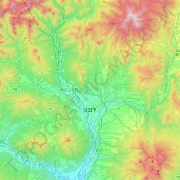
Name: 沼田市 topographic map, elevation, terrain.
Location: 沼田市, 群馬県, 日本 (36.55826 138.98528 36.79701 139.37248)
Average elevation: 824 m
Minimum elevation: 192 m
Maximum elevation: 2,132 m
Other topographic maps
Click on a map to view its topography, its elevation and its terrain.