
群馬県 topographic map
Interactive map
Click on the map to display elevation.
About this map
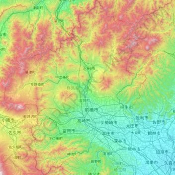
Name: 群馬県 topographic map, elevation, terrain.
Location: 群馬県, 日本 (35.98533 138.39702 37.05863 139.66994)
Average elevation: 768 m
Minimum elevation: 6 m
Maximum elevation: 2,748 m
県域西部から北部にかけて関東山地・三国山脈などの山地が連なり、長野県との県境にある浅間山を始め、新潟県との県境に近い谷川岳、赤城山・榛名山・妙義山の上毛三山がある。県域には日本百名山に数えられる山が11座存在し、これは山梨県と並んで、長野県の29座に次ぐ数である。県域北部の北毛地域にあたる標高の高い山岳地帯では豪雪地帯に指定されることが多く、スキー場も多い。浅間山や草津白根山は活動度が高い活火山であり、国際的な観光地草津温泉を始め伊香保温泉・水上温泉・四万温泉・万座温泉など温泉地が豊富である。
Other topographic maps
Click on a map to view its topography, its elevation and its terrain.