
宇都宮市 topographic map
Interactive map
Click on the map to display elevation.
About this map
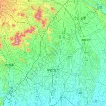
Name: 宇都宮市 topographic map, elevation, terrain.
Location: 宇都宮市, 栃木県, 日本 (36.46397 139.74287 36.73008 140.01076)
Average elevation: 161 m
Minimum elevation: 69 m
Maximum elevation: 549 m
栃木県のほぼ中部、関東平野の中北部に位置し、首都東京から約105km北、標高は市中心部で約100m。北西部に低山地がある以外、土地は概ね平坦である。地層は主に海底土砂の堆積による砂礫層上に軽石層と関東ローム層が形成されている。市域東部には鬼怒川、中央部には田川および釜川、西部には姿川が流れ、それぞれ流域に沖積平野を形成している。市西部は一段高い宝木台地の台上であり、その中央には用水路として掘削された新川が流れる。また市北東部には鬼怒川の治水と流域の田畑開墾、舟運のために整備された西鬼怒川や御用川が流れる。
Other topographic maps
Click on a map to view its topography, its elevation and its terrain.