
高槻市 topographic map
Interactive map
Click on the map to display elevation.
About this map
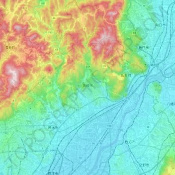
Name: 高槻市 topographic map, elevation, terrain.
Location: 高槻市, 大阪府, 日本 (34.78051 135.55719 34.97676 135.67264)
Average elevation: 171 m
Minimum elevation: -3 m
Maximum elevation: 667 m
大阪府の北東部に位置し、東西10.4km・南北22.7kmと、市域は東西に狭く、南北に広い。北端を北摂連山・南端を淀川で区切られ、地勢は北高南低になっている。市内最高標高はポンポン山の678.7m、最低標高は柱本の淀川河川敷で3.3m。
Other topographic maps
Click on a map to view its topography, its elevation and its terrain.