
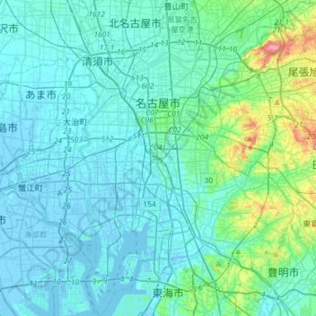
名古屋市 topographic map
Interactive map
Click on the map to display elevation.
About this map
Name: 名古屋市 topographic map, elevation, terrain.
Location: 名古屋市, 愛知県, 中部地方, 日本 (35.02595 136.79197 35.26023 137.06090)
Average elevation: 17 m
Minimum elevation: -12 m
Maximum elevation: 128 m
名古屋市の地形は、東部の丘陵地、中央部の台地、北・西・南部の沖積地の、大きく3つに分かれる。
Other topographic maps
Click on a map to view its topography, its elevation and its terrain.