
関東地方 topographic map
Interactive map
Click on the map to display elevation.
About this map
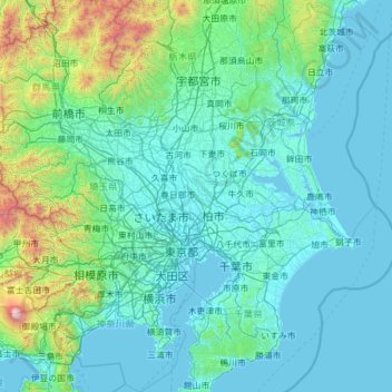
Name: 関東地方 topographic map, elevation, terrain.
Location: 関東地方, 野田市, 千葉県, 278-0005, 日本 (34.95748 138.86706 36.95748 140.86706)
Average elevation: 265 m
Minimum elevation: -3 m
Maximum elevation: 3,662 m
関東平野の表層地質は第四紀の沖積層や洪積層であり、平野部やその周辺の標高約500〜900mの低山の植生は常緑広葉樹林帯。箱根で約900m、丹沢や高尾で約800m、奥多摩、奥武蔵や奥秩父で約700m、西上州や赤城山、足尾山地や筑波山で約600m、北毛や那須の山地で約500mが、照葉樹林の分布限界である。
Other topographic maps
Click on a map to view its topography, its elevation and its terrain.