
千葉県 topographic map
Interactive map
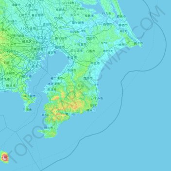
Click on the map to display elevation.
About this map
Name: 千葉県 topographic map, elevation, terrain.
Location: 千葉県, 日本 (34.61682 139.51849 36.10410 141.12493)
Average elevation: 15 m
Minimum elevation: -4 m
Maximum elevation: 705 m
地勢上、広大な可住地と、長大な海岸線を有している。起伏の少ない県であり、関東平野の一部である北部は、海岸(東京湾・太平洋)や河川(利根川・江戸川など)沿いの低地と下総台地からなる。南部側は房総丘陵などの丘陵地帯だが、最高峰は標高408メートルの愛宕山であり、全都道府県のうち最高峰(点)が最も低い。そのため比較的温暖な気候に恵まれている。また、沖縄県以外の都道府県では唯一、冷温帯林が存在しない。標高329メートルの鋸山や鹿野山等、観光地化されているところもあり、南房総国定公園、水郷筑波国定公園等、景勝地も豊富である。
Other topographic maps
Click on a map to view its topography, its elevation and its terrain.