
北九州市 topographic map
Interactive map
Click on the map to display elevation.
About this map
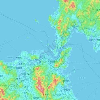
Name: 北九州市 topographic map, elevation, terrain.
Location: 北九州市, 福岡県, 日本 (33.72100 130.48095 34.16884 131.14193)
Average elevation: 53 m
Minimum elevation: -5 m
Maximum elevation: 858 m
これらの山間部は北九州国定公園に指定され、皿倉山は「100億ドルの夜景」として新日本三大夜景に選定されている。福岡県北部から山口県西部にかけては石灰質の地形が拡がり、市内にはカルスト台地の平尾台がある。その他山系の主峰ではないが、公園として整備されている山として、高塔山公園、 中央公園(金比羅山)、 古城山(和布刈公園) などがある。
Other topographic maps
Click on a map to view its topography, its elevation and its terrain.