
Gifu Prefecture topographic map
Interactive map
Click on the map to display elevation.
About this map
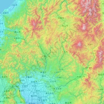
Name: Gifu Prefecture topographic map, elevation, terrain.
Location: Gifu Prefecture, Chubu Region, Japan (35.13373 136.27622 36.46507 137.65305)
Average elevation: 750 m
Minimum elevation: -4 m
Maximum elevation: 3,132 m
Because the Mino region is surrounded by low mountains, the temperature fluctuates through the year, from hot summers to cold winters. The eastern city of Tajimi, for example, often records the hottest temperature in Japan each year and is considered to be the hottest city within Honshu boasting an average daytime high of 34.1 °C (93.4 °F) during the peak of summer. On August 16, 2007, Tajimi set the record for the hottest day recorded in Japan's history—40.9 °C (105.6 °F). Summers are hotter, as the landlocked area becomes a heat island, and the temperature rises even further when hot, dry foehn winds blow over the Ibuki Mountains from the Kansai region. The Hida region, with its higher elevation and northerly latitude, is significantly cooler than the Mino region, although there are sometimes extremely hot days there too. The Hida region is more famous for its harsh winters, bringing extremely heavy snowfall, especially in the northwestern areas. Gifu boasts a high amount of skiing locations. Shōkawa-chō, part of the city of Takayama, is up in the mountains, and its location has led it to be called the coldest inhabited place on Honshū.
Other topographic maps
Click on a map to view its topography, its elevation and its terrain.
Niseko
Niseko, Abuta County, Shiribeshi Subprefecture, Hokkaido Prefecture, Japan
Average elevation: 339 m
Kyoto
Japan > Kinki Region > Kyoto
Higashiyama Ward, Kyoto, Kyoto Prefecture, Kinki Region, Japan
Average elevation: 79 m
Hokkaido
Japan > Hokkaidō Region > Shintoku
Hokkaido, トノカリ2の沢支線林道, Shintoku, Kamikawa, Tokachi Subprefecture, Hokkaidō Prefecture, Hokkaidō Region, Japan
Average elevation: 826 m
Yakushima
Japan > Kyushu Region > Yakushima
Yakushima, Kumage County, Kagoshima Prefecture, Kyushu Region, Japan
Average elevation: 401 m
Zentsuji
Zentsuji, Kagawa Prefecture, Shikoku Region, 765-0003, Japan
Average elevation: 84 m
山王
Japan > Ibaraki Prefecture > Toride > 山王
山王, Toride, Ibaraki Prefecture, Kanto, 300-1537, Japan
Average elevation: 9 m
Kadena
Kadena, Nakagami, Okinawa Prefecture, Kyushu Region, Japan
Average elevation: 49 m
Ashigarashimo District
Hakone, Ashigarashimo District, Kanagawa Prefecture, Kanto, Japan
Average elevation: 722 m
Shibetsu
Shibetsu, Nemuro Subprefecture, Hokkaidō Prefecture, Hokkaidō Region, 086-1632, Japan
Average elevation: 105 m
Nikkō
Japan > Tochigi Prefecture > Nikkō > Nikko
Nikkō, Nikko, Tochigi Prefecture, Kanto, 3211273, Japan
Average elevation: 564 m
湊入船町
Japan > Chubu Region > Toyama > 湊入船町
湊入船町, Toyama, Toyama Prefecture, Chubu Region, 930-0001, Japan
Average elevation: 13 m
Ryukyu Islands
Japan > Kyushu Region > Nago
Ryukyu Islands, Green Street, Nago, Okinawa Prefecture, Kyushu Region, 905-2266, Japan
Average elevation: 4 m
Mt. Tsurugi
Japan > Shikoku Region > Naka
Mt. Tsurugi, Naka, Naka County, Tokushima Prefecture, Shikoku Region, 779-4306, Japan
Average elevation: 1,584 m
Shikoku
Japan > Shikoku Region > Hidaka
Shikoku, Hidaka, Takaoka County, Kochi Prefecture, Shikoku Region, Japan
Average elevation: 156 m
Osaka
Japan > Kinki Region > Osaka
Kita, Osaka, Osaka Prefecture, Kinki Region, Japan
Average elevation: 10 m
Smith Island
Smith Island, Hachijō Subprefecture, Tokyo, Kanto, Japan
Average elevation: 0 m
辺野古岳
Japan > Kyushu Region > Nago
辺野古岳, Nago, Okinawa Prefecture, Kyushu Region, 905-0024, Japan
Average elevation: 143 m
Mooka
Mooka, Tochigi Prefecture, Kanto, 3214334, Japan
Average elevation: 78 m
Tsushima
Tsushima, Nagasaki Prefecture, Kyushu Region, Japan
Average elevation: 7 m
Honshu
Japan > Tohoku > Aizumisato
Honshu, Aizumisato, Onuma, Fukushima Prefecture, Tohoku, Japan
Average elevation: 91 m