
京都市 topographic map
Interactive map
Click on the map to display elevation.
About this map
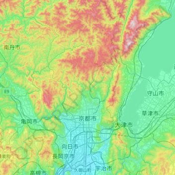
Name: 京都市 topographic map, elevation, terrain.
Location: 京都市, 京都府, 日本 (34.87492 135.55901 35.32122 135.87844)
Average elevation: 311 m
Minimum elevation: 5 m
Maximum elevation: 1,182 m
また、眺望景観保全地域として、東寺、清水寺などからの境内の眺めや、円通寺などからの庭園の眺め、鴨川からの大文字の眺めなど、38箇所からの眺望を指定し、その周辺をデザイン保全区域として、標高規制やデザインの規制がされる。
Other topographic maps
Click on a map to view its topography, its elevation and its terrain.