
つくば市 topographic map
Interactive map
Click on the map to display elevation.
About this map
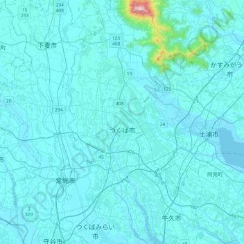
Name: つくば市 topographic map, elevation, terrain.
Location: つくば市, 茨城県, 日本 (35.94732 139.99579 36.23683 140.17315)
Average elevation: 35 m
Minimum elevation: -1 m
Maximum elevation: 843 m
市を代表する観光地である筑波山は、市北部に位置する。筑波山周辺を除き、関東平野の一部であり筑波台地や稲敷台地と呼ばれる標高20m~標高30mの平坦な地形であり、関東ローム層に覆われている。また、つくば市の9月の標高は4月の標高より2cm低くなるが、市内にある国土地理院の研究によると、5月から8月に水田灌漑用として大量の地下水をくみ上げるためである(台地上のため地下水をくみ上げる必要がある)。
Other topographic maps
Click on a map to view its topography, its elevation and its terrain.