
麻生区 topographic map
Interactive map
Click on the map to display elevation.
About this map
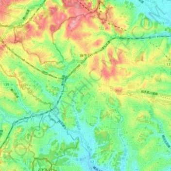
Name: 麻生区 topographic map, elevation, terrain.
Location: 麻生区, 川崎市, 神奈川県, 日本 (35.56713 139.44889 35.62491 139.53194)
Average elevation: 67 m
Minimum elevation: 22 m
Maximum elevation: 132 m
川崎市の西北端に位置し多摩丘陵の一部を占める。南北に長い市域を持つ川崎市の中で、行政の中心である市の南東部の川崎区とは最も離れている。区域全体が丘陵地帯にあり標高は高めで、市内で最も標高が高い地点も麻生区内にある。区の中央から西に流れる麻生川沿いは標高がやや低くなっている。
Other topographic maps
Click on a map to view its topography, its elevation and its terrain.