
西東京市 topographic map
Interactive map
Click on the map to display elevation.
About this map
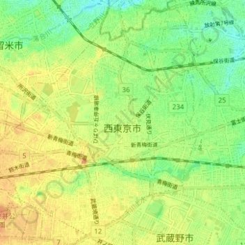
Name: 西東京市 topographic map, elevation, terrain.
Location: 西東京市, 東京都, 日本 (35.71121 139.51670 35.76156 139.56947)
Average elevation: 59 m
Minimum elevation: 42 m
Maximum elevation: 73 m
地形的には武蔵野台地のほぼ中央に位置し、関東ローム層に覆われている。水利の便の乏しい多摩地域にあって市内に石神井川、白子川、新川(白子川支流)と玉川上水から分水した千川上水があり、比較的水利に恵まれた土地である。市域は東西4.8キロメートル、南北に5.6キロメートル、北側がすぼまった葉の形をしている。区部と境界を接している隣接5市の内の一つである。
Other topographic maps
Click on a map to view its topography, its elevation and its terrain.