
長野市 topographic map
Interactive map
Click on the map to display elevation.
About this map
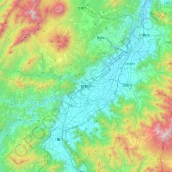
Name: 長野市 topographic map, elevation, terrain.
Location: 長野市, 長野県, 中部地方, 日本 (36.46070 137.91010 36.83573 138.31890)
Average elevation: 828 m
Minimum elevation: 310 m
Maximum elevation: 2,332 m
市内にある県庁本庁舎は、標高371.3メートルの地点に建っており、日本の47都道府県庁舎の中で最も高い場所にあるものである。
Other topographic maps
Click on a map to view its topography, its elevation and its terrain.