
相模原市 topographic map
Interactive map
Click on the map to display elevation.
About this map
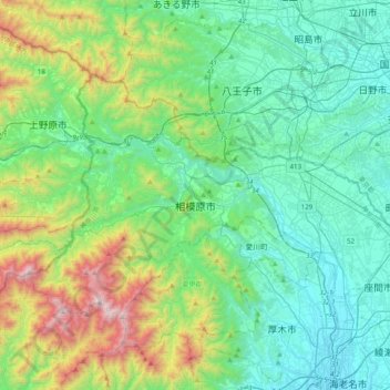
Name: 相模原市 topographic map, elevation, terrain.
Location: 相模原市, 神奈川県, 日本 (35.47455 139.06604 35.67290 139.45848)
Average elevation: 380 m
Minimum elevation: 9 m
Maximum elevation: 1,646 m
相模川左岸の相模原台地上に位置する平坦な東部・旧相模原市域(中央区・南区および緑区東部)と、南の丹沢山地と北の高尾山・陣馬山などの間に広がる山地を相模川などが刻み、河岸段丘上にわずかな平坦面が散在する西部・津久井地域(旧津久井郡、緑区の大半)とに分けることができる。人口は東部に集中している。ただし、津久井地域のうち旧城山町東部は地形的に連続する旧相模原市域と合わせて相模原台地の一部として理解するのが適当である。直下には伊勢原断層が所在している。
Other topographic maps
Click on a map to view its topography, its elevation and its terrain.