
長崎県 topographic map
Interactive map
Click on the map to display elevation.
About this map
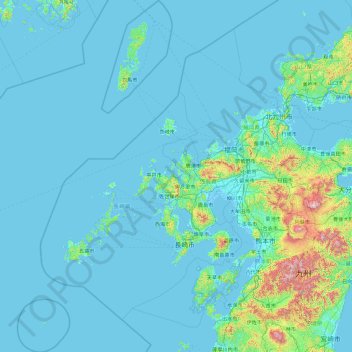
Name: 長崎県 topographic map, elevation, terrain.
Location: 長崎県, 日本 (31.78493 128.10833 34.89174 130.48195)
Average elevation: 89 m
Minimum elevation: -4 m
Maximum elevation: 1,725 m
五島列島、壱岐島、対馬など数多くの島嶼を含み、47都道府県中最も島が多いことで知られる。また、多島であるうえにリアス式海岸を多く擁することから海岸線の長さは47都道府県中第2位もしくは第1位となっている(※「地形」節にて詳説)。
Other topographic maps
Click on a map to view its topography, its elevation and its terrain.