
生駒市 topographic map
Interactive map
Click on the map to display elevation.
About this map
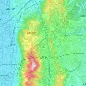
Name: 生駒市 topographic map, elevation, terrain.
Location: 生駒市, 奈良県, 日本 (34.64649 135.67007 34.78136 135.75706)
Average elevation: 138 m
Minimum elevation: 0 m
Maximum elevation: 641 m
奈良県の北西端に位置し、南北に細長く生駒山地や矢田丘陵などの山々に囲まれた山間の市。市街地にも小高い丘や山が点在しており、平地の乏しい複雑な地形をしている。
Other topographic maps
Click on a map to view its topography, its elevation and its terrain.