
剣ヶ峰 topographic map
Interactive map
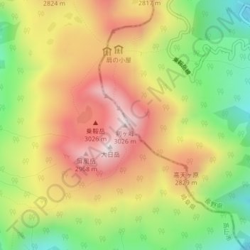
Click on the map to display elevation.
About this map
Name: 剣ヶ峰 topographic map, elevation, terrain.
Location: 剣ヶ峰, 高山市, 岐阜県, 日本 (36.10647 137.55357 36.10657 137.55367)
Average elevation: 2,685 m
Minimum elevation: 2,351 m
Maximum elevation: 3,008 m
乗鞍岳(のりくらだけ)は、飛騨山脈南部の長野県松本市と岐阜県高山市にまたがる剣ヶ峰(標高3,026m)を主峰とする山々の総称。山頂部の権現池火口の外輪山に位置する最高峰の剣ヶ峰、朝日岳などの8峰を含め、摩利支天岳、富士見岳など23の峰があり、高山市奥飛騨温泉郷、高山市丹生川町、高山市朝日町、高山市高根町、長野県松本市安曇にまたがる広大な裾野をもつ。飛騨側の高山市街地などから大きな山容を望むことができ、親しまれてきた山である。剣ヶ峰は、本州を太平洋側と日本海側に分ける分水界上の最高峰でもある。
Other topographic maps
Click on a map to view its topography, its elevation and its terrain.