
ジャンダルム topographic map
Interactive map
Click on the map to display elevation.
About this map
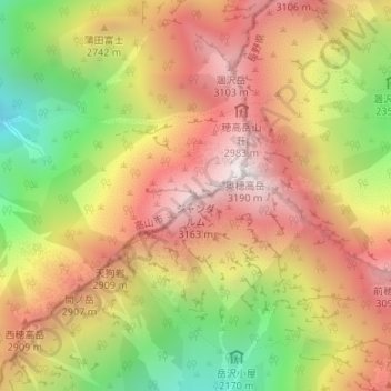
Name: ジャンダルム topographic map, elevation, terrain.
Location: ジャンダルム, 高山市, 岐阜県, 日本 (36.28764 137.64363 36.28774 137.64373)
Average elevation: 2,633 m
Minimum elevation: 1,941 m
Maximum elevation: 3,185 m
ジャンダルム (Gendarme) は、飛騨山脈(北アルプス)穂高連峰・奥穂高岳の西南西にあるドーム型の岩稜。標高は3,163 m。
Other topographic maps
Click on a map to view its topography, its elevation and its terrain.