
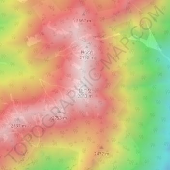
抜戸岳 topographic map
Interactive map
Click on the map to display elevation.
About this map
Name: 抜戸岳 topographic map, elevation, terrain.
Location: 抜戸岳, 高山市, 岐阜県, 506-1421, 日本 (36.32761 137.57511 36.32771 137.57521)
Average elevation: 2,374 m
Minimum elevation: 1,677 m
Maximum elevation: 2,803 m
抜戸岳(ぬけどだけ)は、岐阜県高山市にある飛騨山脈南部の標高2,812.8 mの山。
Other topographic maps
Click on a map to view its topography, its elevation and its terrain.