
御母衣湖 topographic map
Interactive map
Click on the map to display elevation.
About this map
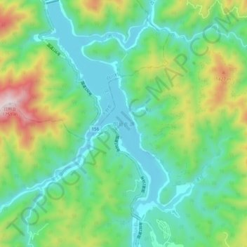
Name: 御母衣湖 topographic map, elevation, terrain.
Location: 御母衣湖, 高山市, 白川村, 大野郡, 岐阜県, 日本 (36.06104 136.90755 36.13804 136.96424)
Average elevation: 996 m
Minimum elevation: 712 m
Maximum elevation: 1,729 m
Other topographic maps
Click on a map to view its topography, its elevation and its terrain.