
弓折岳 topographic map
Interactive map
Click on the map to display elevation.
About this map
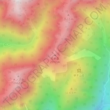
Name: 弓折岳 topographic map, elevation, terrain.
Location: 弓折岳, 高山市, 岐阜県, 日本 (36.34947 137.59647 36.34957 137.59657)
Average elevation: 2,298 m
Minimum elevation: 1,697 m
Maximum elevation: 2,733 m
弓折岳(ゆみおりだけ、ゆみおれだけ)は、岐阜県高山市にある飛騨山脈南部の標高2,592 mの山。弓折岳を含む飛騨山脈の主な山域は1934年(昭和9年)12月4日に中部山岳国立公園の指定を受けている。山頂は台地状。花の百名山、続ぎふ百山の一つに選定されている。東山腹にある鏡平が、新高山市100景の一つに選定されている。
Other topographic maps
Click on a map to view its topography, its elevation and its terrain.