
福島市 topographic map
Interactive map
Click on the map to display elevation.
About this map
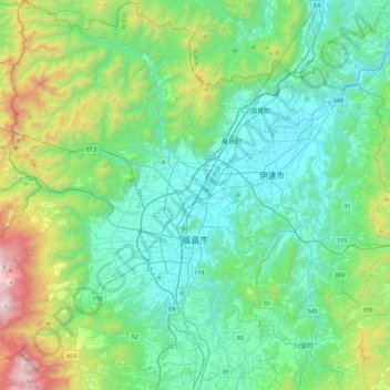
Name: 福島市 topographic map, elevation, terrain.
Location: 福島市, 福島県, 日本 (37.62421 140.22926 37.97665 140.56998)
Average elevation: 398 m
Minimum elevation: 22 m
Maximum elevation: 1,781 m
福島市は福島県の北東部に位置し、猪苗代湖から北東へ約50kmに位置している。東京から北へ約260kmの距離である。西側の奥羽山脈と東側の阿武隈高地に挟まれた福島盆地の南西部分とその周辺の山岳・丘陵地域が主な市域である。市内からは西に吾妻連峰を、南西に安達太良山を仰ぐ。福島県内陸では最も標高が低い位置にある。
Other topographic maps
Click on a map to view its topography, its elevation and its terrain.