
御殿場市 topographic map
Interactive map
Click on the map to display elevation.
About this map
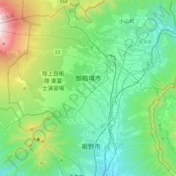
Name: 御殿場市 topographic map, elevation, terrain.
Location: 御殿場市, 静岡県, 中部地方, 日本 (35.21482 138.73169 35.36197 138.99319)
Average elevation: 792 m
Minimum elevation: 140 m
Maximum elevation: 3,054 m
御殿場市(ごてんばし)は、静岡県東部に位置する人口約8.5万人の市。富士山周辺・箱根観光への交通拠点となっている高原都市である。標高が高いことから気候は冷涼で降水量が多い。
Other topographic maps
Click on a map to view its topography, its elevation and its terrain.