
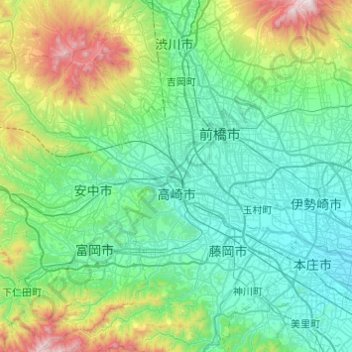
高崎市 topographic map
Interactive map
Click on the map to display elevation.
About this map
Name: 高崎市 topographic map, elevation, terrain.
Location: 高崎市, 群馬県, 日本 (36.19859 138.64251 36.48347 139.12966)
Average elevation: 331 m
Minimum elevation: 36 m
Maximum elevation: 1,555 m
また、海岸より100 km以上離れた内陸に位置するにもかかわらず、中心市街地の標高は97.1 m(高崎市役所)と低い。また、市の北部及び西部には標高1,000 m以上の地点も存在し、倉渕町川浦の浅間隠山にある東吾妻町及び、長野原町との境界では標高1,690 m、新町の烏川河川敷の標高60 mと標高差が1,630 mもある。
Other topographic maps
Click on a map to view its topography, its elevation and its terrain.