
西宮市 topographic map
Interactive map
Click on the map to display elevation.
About this map
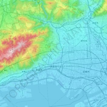
Name: 西宮市 topographic map, elevation, terrain.
Location: 西宮市, 兵庫県, 662-8567, 日本 (34.66326 135.22970 34.86133 135.38432)
Average elevation: 136 m
Minimum elevation: -9 m
Maximum elevation: 916 m
Other topographic maps
Click on a map to view its topography, its elevation and its terrain.