
手稲区 topographic map
Interactive map
Click on the map to display elevation.
About this map
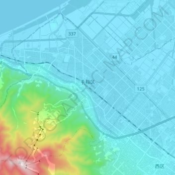
Name: 手稲区 topographic map, elevation, terrain.
Location: 手稲区, 札幌市, 石狩振興局, 北海道, 日本 (43.07639 141.15196 43.16034 141.28628)
Average elevation: 123 m
Minimum elevation: -1 m
Maximum elevation: 1,014 m
Other topographic maps
Click on a map to view its topography, its elevation and its terrain.