
定山渓 topographic map
Interactive map
Click on the map to display elevation.
About this map
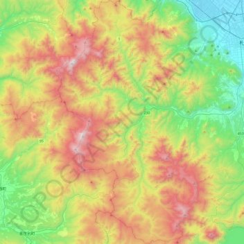
Name: 定山渓 topographic map, elevation, terrain.
Location: 定山渓, 南区, 札幌市, 石狩振興局, 北海道, 日本 (42.78071 140.99050 43.12048 141.25670)
Average elevation: 597 m
Minimum elevation: 4 m
Maximum elevation: 1,480 m
Other topographic maps
Click on a map to view its topography, its elevation and its terrain.