
厚別区 topographic map
Interactive map
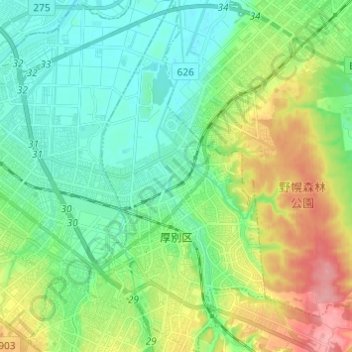
Click on the map to display elevation.
About this map
Name: 厚別区 topographic map, elevation, terrain.
Location: 厚別区, 札幌市, 石狩振興局, 北海道, 日本 (43.00706 141.44385 43.09612 141.50542)
Average elevation: 33 m
Minimum elevation: 1 m
Maximum elevation: 101 m
厚別区は札幌市10区の中では最も面積の小さな区である。標高7 mほどの平野部と標高40 mほどの丘陵部に分かれており、丘陵部は地質学的に野津幌川を境に北側を「野幌丘陵」、南側を「厚別台地」と呼ばれている。江別市と北広島市にかけてある「道立自然公園野幌森林公園」は、日本国内では数少ない大都市近郊においてまとまった森林(平地林)が残されている。
Other topographic maps
Click on a map to view its topography, its elevation and its terrain.