
保土ヶ谷区 topographic map
Interactive map
Click on the map to display elevation.
About this map
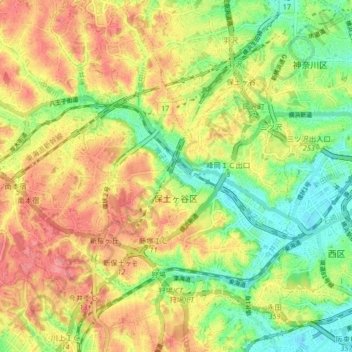
Name: 保土ヶ谷区 topographic map, elevation, terrain.
Location: 保土ヶ谷区, 横浜市, 神奈川県, 231-0017, 日本 (35.43127 139.54494 35.49826 139.60801)
Average elevation: 46 m
Minimum elevation: 0 m
Maximum elevation: 92 m
Other topographic maps
Click on a map to view its topography, its elevation and its terrain.