
川和富士公園 topographic map
Interactive map
Click on the map to display elevation.
About this map
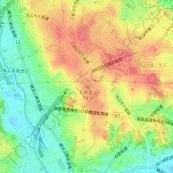
Name: 川和富士公園 topographic map, elevation, terrain.
Location: 川和富士公園, 富士見が丘, 都筑区, 横浜市, 神奈川県, 231-0017, 日本 (35.53206 139.55568 35.53392 139.55804)
Average elevation: 40 m
Minimum elevation: 6 m
Maximum elevation: 70 m
川和富士は、江戸時代末期の1860年(万延元年)に富士講によってに築かれた富士塚で、川和富士塚遺跡の範囲に所在した。元々は現在地より川和高校寄りの地点(現在の富士見が丘17番14)にあったが、港北ニュータウン建設に伴う遺跡調査(港北ニュータウン遺跡群調査)の一環で1977年(昭和52年)~1978年(昭和53年)に発掘調査され、現在の場所に移転・再現された。標高は74メートル。なお現在地の公園は、本来、猫谷戸台遺跡という川和富士塚遺跡とは全く別の遺跡があった場所である。
Other topographic maps
Click on a map to view its topography, its elevation and its terrain.