
Make a donation
Zambia topographic map
Click on the map to display elevation.
Make a donation
Zambia
Zambia is located on the plateau of Central Africa, between 1,000 and 1,600 metres (3,300 and 5,200 ft) above sea level. The average elevation of 1,200 metres (3,900 ft) gives the land a generally moderate climate. The climate of Zambia is tropical, modified by elevation. In the Köppen climate classification, most of the country is classified as humid subtropical or tropical wet and dry, with small stretches of semi-arid steppe climate in the south-west and along the Zambezi valley.
Make a donation
About this map
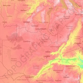
Name: Zambia topographic map, elevation, terrain.
Location: Zambia (-18.07621 21.99906 -8.27493 33.70886)
Average elevation: 1,074 m
Minimum elevation: 223 m
Maximum elevation: 2,528 m
Make a donation
Other topographic maps
Click on a map to view its topography, its elevation and its terrain.
Vienna
Vienna is located in northeastern Austria, at the easternmost extension of the Alps in the Vienna Basin. The earliest settlement, at the location of today's inner city, was south of the meandering Danube while the city now spans both sides of the river. Elevation ranges from 151 to 542 m (495 to 1,778 ft). The…
Average elevation: 231 m
Make a donation
Chinsali
The geographical coordinates of Chinsali Town are 10°33'08.0"S, 32°04'09.0"E (Latitude:-10.552222; Longitude:32.069167). The town is nestled at an average elevation of 1,383 metres (4,537 ft) above mean sea level.
Average elevation: 1,294 m
Make a donation
Solwezi
Zambia > North-Western Province
Solwezi is located on the Chingola–Solwezi–Mwinilunga Road (T5 Road of Zambia), approximately 177 kilometres (110 mi) north-west of Chingola and approximately 275 kilometres (171 mi) south-east of Mwinilunga, in the extreme northwest of the country. The geographical coordinates of the city…
Average elevation: 1,352 m
Mbala
The town is at the edge of the plateau covering most of Zambia, at an elevation of 1670 m, about 900 m higher than Lake Tanganyika, which comes within 22 km (straight-line distance). The escarpment above the lake is the end of the Albertine Rift, the western branch of the East Africa Rift, and the Mbala area…
Average elevation: 1,632 m
Make a donation
Nakonde
This is approximately 350 kilometres (217 mi), by road, north of Mpika, the largest city in the province. The geographical coordinates of the town are: 09°19'38.0"S, 32°45'30.0"E (Latitude:-9.327222; Longitude:32.758333). The average elevation of Nakonde is about 1,306 metres (4,285 ft), above sea level.…
Average elevation: 1,613 m
Make a donation
Make a donation
Make a donation
Chadiza
Chadiza is a town in the Eastern Province of Zambia. Its headquarters are located in Chadiza District. It lies 35 km south of the Great East Road and about 80 km south-south-west of Chipata, on a plateau (elevation 1050 m) studded by isolated rocky hills, between the middle Luangwa valley and the Zambezi. It…
Average elevation: 1,055 m
Make a donation
Choma
Choma lies on the Lusaka–Livingstone Road, approximately 292 kilometres (181 mi) south-west of Lusaka, the national capital and largest city in Zambia. This is approximately 194 kilometres (121 mi), by road, northeast of Livingstone, the largest city in Zambia's Southern Province. The geographical…
Average elevation: 1,310 m
Make a donation
Make a donation
Make a donation
Mount Santo Tomas
Due to its high elevation, several communications and broadcasting companies constructed relay stations at the summit.
Average elevation: 1,741 m
Make a donation
Hlabisa
South Africa > KwaZulu-Natal > Umkhanyakude District Municipality > Hlabisa Local Municipality
Average elevation: 482 m
Centurion
South Africa > Gauteng > City of Tshwane Metropolitan Municipality
Average elevation: 1,451 m
Make a donation
Arusha
Despite its proximity to the equator, Arusha's elevation of 1,400 metres (4,600 ft) on the southern slopes of Mount Meru keeps temperatures relatively low and alleviates humidity. Cool dry air is prevalent for much of the year. The temperature typically ranges between 10 and 30 °C (50 and 86 °F) with an…
Average elevation: 1,572 m
Make a donation
Make a donation
Make a donation
Make a donation
Make a donation
Baabdat
Lebanon > Mount Lebanon Governorate
Baabdat (Arabic: بعبدات) is a town located in the Matn District of Mount Lebanon, 22 km from Beirut at an altitude ranging between 600 and 1100 meters above sea level. The lush pine forests that surround the town make it a very popular summer resort for those escaping the busy coastal cities of Lebanon,…
Average elevation: 740 m
Bugojno
Bosnia and Herzegovina > Federation of Bosnia and Herzegovina
The municipality has an average elevation of 570 metres above sea level. Much of its 366 km sq. is forested. The terrain is mountainous with several prominent features. Stožer (1,662 m), Kalin (1,530 m) and Rudina (1,385 m) are the tallest mountains in Bugojno.
Average elevation: 647 m
Make a donation
Sebokeng
South Africa > Gauteng > Sedibeng District Municipality > Emfuleni Local Municipality
Average elevation: 1,523 m
Umgwenya
South Africa > Mpumalanga > Ehlanzeni District Municipality > Thaba Chweu Local Municipality
Average elevation: 1,211 m
Ma'uŋa Te Hoŋa (O Koro)
Chile > Valparaiso Region > Easter Island Province > Easter Island
Average elevation: 255 m
Make a donation
Make a donation
Make a donation
Make a donation
Ida
The summit is windswept and bare with a relatively low tree line due to exposure, but the slopes of this mountain, at the edge of mild Mediterranean and colder central Anatolian climate zones, hold a wealth of endemic flora, marooned here after the Ice Age. The climate at lower altitudes has become…
Average elevation: 1,457 m
Make a donation
Gjeravica
Gjeravica (Albanian indefinite form: Gjeravicë; Serbian: Ђеравица / Đeravica) is a mountain peak in Kosovo. It also is the second-highest mountain peak in the Accursed Mountains range and the Dinaric Alps range, after Jezercë. It has an elevation of 2,656 m (8,714 ft) above sea level. Gjeravica is…
Average elevation: 2,214 m
Make a donation
Swat
Pakistan > Khyber Pakhtunkhwa > Charsadda District > بانڈہ سیداں > بِجلۍ کورونه
Average elevation: 370 m
Islamabad
Pakistan > Islamabad Capital Territory
Islamabad's micro-climate is regulated by three artificial reservoirs: Rawal, Simli, and Khanpur Dam. The latter is located on the Haro River near the town of Khanpur, about 40 kilometres (25 mi) from Islamabad. Simli Dam is 30 kilometres (19 mi) north of Islamabad. 220 acres (89 ha) of the city consists of…
Average elevation: 666 m
Make a donation