
Make a donation
Chinsali topographic map
Click on the map to display elevation.
Make a donation
Chinsali
The geographical coordinates of Chinsali Town are 10°33'08.0"S, 32°04'09.0"E (Latitude:-10.552222; Longitude:32.069167). The town is nestled at an average elevation of 1,383 metres (4,537 ft) above mean sea level.
Make a donation
About this map
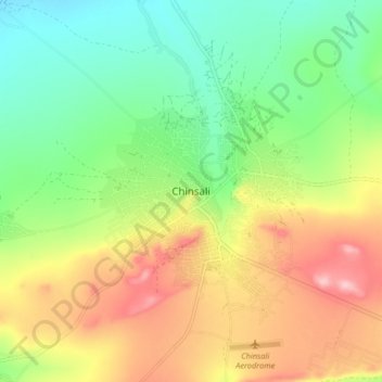
Name: Chinsali topographic map, elevation, terrain.
Location: Chinsali, Chinsali District, Muchinga Province, Zambia (-10.58997 32.02608 -10.50997 32.10608)
Average elevation: 1,294 m
Minimum elevation: 1,219 m
Maximum elevation: 1,398 m
Make a donation
Other topographic maps
Click on a map to view its topography, its elevation and its terrain.
South Luangwa National Park
The park spans two eco-regions, both of them woodland savannah, distinguished by the dominant tree: Southern Miombo woodlands cover the higher slopes of the valley, while Zambezian and Mopane woodlands cover the bottom of the valley. The Mopane tree tolerates the higher temperatures and lower rainfall found at…
Average elevation: 854 m
Make a donation