
Thank you for supporting this site ❤️
Make a donation
Make a donation
Chongwe topographic map
Click on the map to display elevation.
Thank you for supporting this site ❤️
Make a donation
Make a donation
About this map
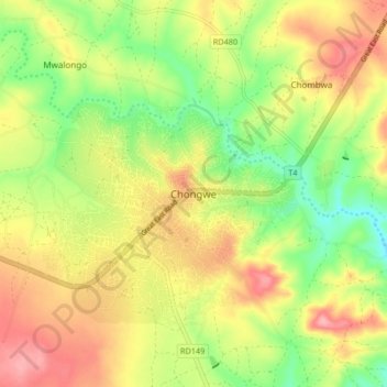
Name: Chongwe topographic map, elevation, terrain.
Location: Chongwe, Chongwe District, Lusaka Province, Zambia (-15.36748 28.64134 -15.28748 28.72134)
Average elevation: 1,087 m
Minimum elevation: 1,031 m
Maximum elevation: 1,143 m
Thank you for supporting this site ❤️
Make a donation
Make a donation
Other topographic maps
Click on a map to view its topography, its elevation and its terrain.