
Thank you for supporting this site ❤️
Make a donation
Make a donation
Mulungushi topographic map
Click on the map to display elevation.
Thank you for supporting this site ❤️
Make a donation
Make a donation
About this map
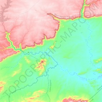
Name: Mulungushi topographic map, elevation, terrain.
Location: Mulungushi, Luano District, Central Province, Zambia (-14.90305 28.82360 -14.69709 29.19466)
Average elevation: 736 m
Minimum elevation: 467 m
Maximum elevation: 1,163 m
Thank you for supporting this site ❤️
Make a donation
Make a donation
Other topographic maps
Click on a map to view its topography, its elevation and its terrain.