
Thank you for supporting this site ❤️
Make a donation
Make a donation
Gwembe topographic map
Click on the map to display elevation.
Thank you for supporting this site ❤️
Make a donation
Make a donation
About this map
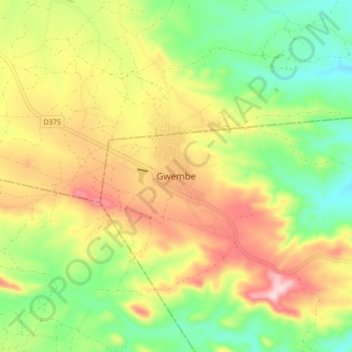
Name: Gwembe topographic map, elevation, terrain.
Location: Gwembe, Gwembe District, Southern Province, Zambia (-16.53753 27.56497 -16.45753 27.64497)
Average elevation: 1,182 m
Minimum elevation: 1,054 m
Maximum elevation: 1,340 m
Thank you for supporting this site ❤️
Make a donation
Make a donation
Other topographic maps
Click on a map to view its topography, its elevation and its terrain.