
Thank you for supporting this site ❤️
Make a donation
Make a donation
Vienna topographic map
Click on the map to display elevation.
Thank you for supporting this site ❤️
Make a donation
Make a donation
Vienna
Vienna is located in northeastern Austria, at the easternmost extension of the Alps in the Vienna Basin. The earliest settlement, at the location of today's inner city, was south of the meandering Danube while the city now spans both sides of the river. Elevation ranges from 151 to 542 m (495 to 1,778 ft). The city has a total area of 414.65 square kilometres (160.1 sq mi), making it the largest city in Austria by area.
Thank you for supporting this site ❤️
Make a donation
Make a donation
About this map
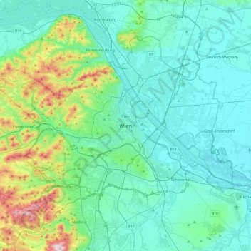
Name: Vienna topographic map, elevation, terrain.
Location: Vienna, 1010, Austria (48.04835 16.21250 48.36835 16.53250)
Average elevation: 231 m
Minimum elevation: 145 m
Maximum elevation: 650 m
Thank you for supporting this site ❤️
Make a donation
Make a donation