
佐渡市 topographic map
Interactive map
Click on the map to display elevation.
About this map
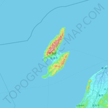
Name: 佐渡市 topographic map, elevation, terrain.
Location: 佐渡市, 新潟県, 中部地方, 日本 (37.50256 137.53163 38.60630 138.91504)
Average elevation: 16 m
Minimum elevation: -8 m
Maximum elevation: 1,079 m
都市ガスは、両津地区の一部で佐渡ガスが供給している。地形上の制約もあり、大半の地区ではLPガスを使用する。
Other topographic maps
Click on a map to view its topography, its elevation and its terrain.