
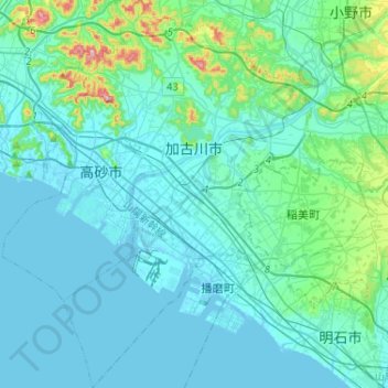
加古川市 topographic map
Interactive map
Click on the map to display elevation.
About this map
Name: 加古川市 topographic map, elevation, terrain.
Location: 加古川市, 兵庫県, 日本 (34.65470 134.76261 34.86720 134.93618)
Average elevation: 34 m
Minimum elevation: -3 m
Maximum elevation: 283 m
播磨平野の東部に位置しており、市内を一級河川の加古川が貫流している。加古川の左岸側の市域は全体的に平坦である。これに対して、加古川の右岸側の市域には平坦な場所も存在するものの、山頂が高砂市との市境である高御位山を始め、加古川市内の大藤山・飯盛山などの標高200 mを超える山も見られる。なお加古川の河口近くは高砂市との行政境界であり、加古川市域は左岸側である。
Other topographic maps
Click on a map to view its topography, its elevation and its terrain.