
Make a donation
Seto Inland Sea topographic map
Click on the map to display elevation.
Make a donation
About this map
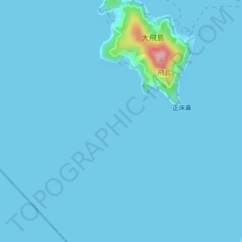
Name: Seto Inland Sea topographic map, elevation, terrain.
Location: Seto Inland Sea (34.33328 133.49995 34.33338 133.50005)
Average elevation: 5 m
Minimum elevation: 0 m
Maximum elevation: 136 m
Make a donation
Other topographic maps
Click on a map to view its topography, its elevation and its terrain.
Zambia
Zambia is located on the plateau of Central Africa, between 1,000 and 1,600 metres (3,300 and 5,200 ft) above sea level. The average elevation of 1,200 metres (3,900 ft) gives the land a generally moderate climate. The climate of Zambia is tropical, modified by elevation. In the Köppen climate classification,…
Average elevation: 1,074 m
Kafue
The Kafue River rises at an elevation of 1350 m on the relatively flat plateau just south the border between Zambia and the Democratic Republic of the Congo 120 km north-west of Chingola in the Copperbelt Province. The source of the Kafue River is in the North-western Province of Zambia. The area is Miombo…
Average elevation: 1,177 m
Make a donation
Luangwa
Note: distances stated are approximate straight-line distances from source. The Luangwa rises in the Lilonda and Mafinga Hills in north-east Zambia at an elevation of around 1,500 metres (4,900 ft), near the border with Tanzania and Malawi, and flows in a southwesterly direction through a broad valley. About…
Average elevation: 996 m
Northern Province
The Northern Province lies mainly on the great southern African plateau, which has been uplifted to an elevation around 1200 metres above sea level. Rift valleys extend clockwise around the province from the north-west to the south. These rift valleys are sometimes outside the borders of the province, as in…
Average elevation: 1,289 m
Southern Province
Southern Province is bordered along Zimbabwe in the south divided by Victoria Falls, Central in the north, Western Province in the west and Lusaka Province in the northeast. The general topography of the province is characterized by uplifted planation surfaces. The general elevation of the nation as a whole is…
Average elevation: 1,007 m
Make a donation
Lusaka Province
Lusaka Province is bordered along Zimbabwe along Lower Zambezi National Park in the south, Central Province in the north, Southern Province in the southwest and Eastern Province in the north east. The general topography of the province is characterized by uplifted plantation surfaces. The general elevation of…
Average elevation: 866 m
Make a donation
Chinsali District
It lies on the watershed between the Chambeshi River in the Congo Basin and the Luangwa River in the Zambezi basin. The north-eastern half of the district is relatively flat plateau, especially along the Chambeshi, of 1200–1300 m elevation but the south-western half has an attractive landscape of granite…
Average elevation: 1,234 m
Make a donation
Make a donation
Make a donation
Make a donation
New York
The city's land has been altered substantially by human intervention, with considerable land reclamation along the waterfronts since Dutch colonial times; reclamation is most prominent in Lower Manhattan, with developments such as Battery Park City in the 1970s and 1980s. Some of the natural relief in…
Average elevation: 19 m
Make a donation
Côte d'Ivoire
Average elevation: 244 m
Thyspunt
South Africa > Eastern Cape > Sarah Baartman District Municipality > Kouga Local Municipality > Oyster Bay
Average elevation: 82 m
Make a donation
Make a donation
Make a donation
Manhattan
United States > New York > New York County > New York
Parkland covers a total of 2,659 acres (10.76 km2), accounting for 18.2% of the borough's land area; the 840-acre (3.4 km2) Central Park is the borough's largest park, comprising 31.6% of Manhattan's parkland. Designed by Frederick Law Olmsted and Calvert Vaux, the park is anchored by the 12-acre (4.9 ha)…
Average elevation: 16 m
City of Poughkeepsie
United States > New York > Dutchess County
According to the United States Census Bureau, the city has an area of 5.7 square miles (14.8 km2), of which 5.1 square miles (13.3 km2) is land, and 0.23 square miles (0.6 km2) (comprising 10.05%) is water. Poughkeepsie lies approximately 75 miles (121 km) north of the center of the New York megacity. It is…
Average elevation: 49 m
Make a donation
Make a donation
Zamora Chinchipe
Zamora Chinchipe (Spanish pronunciation: [saˈmoɾa tʃinˈtʃipe]), Province of Zamora Chinchipe is a province of the Republic of Ecuador, located at the southeastern end of the Amazon Basin, which shares borders with the Ecuadorian provinces of Azuay and Morona Santiago to the north, Loja and Azuay to the…
Average elevation: 1,548 m
Mexico
Mexico's topography is characterized by a remarkable diversity, featuring rugged mountains, expansive plateaus, and lush coastal plains. The Sierra Madre Occidental and Sierra Madre Oriental mountain ranges run parallel to the country's western and eastern coasts, respectively, creating a central highland…
Average elevation: 412 m
Make a donation
Durango
The area of Durango is 123,451.2 km2 or 12.3 million ha; this accounts for about 6.3% of the entire territory of Mexico. It is the fourth largest state, lying at the extreme northwest of the Central Mexican Plateau, where it meets the Sierra Madre Occidental—the highest peaks in the state. The state has an…
Average elevation: 1,580 m
Make a donation
Quebec
Quebec's topography is very different from one region to another due to the varying composition of the ground, the climate, and the proximity to water. More than 95% of Quebec's territory, including the Labrador Peninsula, lies within the Canadian Shield. It is generally a quite flat and exposed mountainous…
Average elevation: 195 m
Make a donation
Umgwenya
South Africa > Mpumalanga > Ehlanzeni District Municipality > Thaba Chweu Local Municipality
Average elevation: 1,211 m
Make a donation
Isla Isabela
One of the youngest islands, Isabela is located on the western edge of the archipelago near the Galápagos hotspot. At approximately 1 million years old, the seahorse-shaped island was formed by the merger of six shield volcanoes; Alcedo, Cerro Azul, Darwin, Ecuador, Sierra Negra, and Wolf. All of these…
Average elevation: 96 m
Make a donation
Anhui
Anhui is topographically diverse. The north is part of the North China Plain while the north-central areas are part of the Huai River watershed. Both regions are flat, and densely populated. The land becomes more uneven further south, with the Dabie Mountains occupying much of southwestern Anhui and a series…
Average elevation: 99 m
Turkey
Turkey's topography is a diverse tapestry of mountains, plateaus, and coastal plains that create a strikingly varied landscape. The country is predominantly characterized by the Anatolian Plateau, a semi-arid highland that stretches across central Turkey, with elevations ranging from 700 to 2,000 meters. This…
Average elevation: 487 m
Make a donation
Zimbabwe
Zimbabwe is a landlocked country in southern Africa, lying between latitudes 15° and 23°S, and longitudes 25° and 34°E. It is bordered by South Africa to the south, Botswana to the west and southwest, Zambia to the northwest, and Mozambique to the east and northeast. Its northwest corner is roughly 150…
Average elevation: 869 m
Make a donation
Malta
Average elevation: 4 m
Florida
Florida's topography is characterized by its predominantly flat landscape, with the highest elevation being Britton Hill at just 345 feet (105 meters) above sea level, making it the lowest high point of any U.S. state. The state is primarily divided into three physiographic regions: the Atlantic Coastal Plain,…
Average elevation: 6 m
Make a donation
Guinea-Bissau
At 36,125 square kilometres (13,948 sq mi), the country is larger in size than Belgium. The highest point is Monte Torin with an elevation of 262 metres (860 ft). Its terrain is mostly low coastal plains with swamps of the Guinean mangroves rising to the Guinean forest–savanna mosaic in the east. Its…
Average elevation: 34 m
Đakovo
Croatia > Osijek-Baranja County
Đakovo is located 37 km (23 mi) to the southwest of Osijek and 34 km (21 mi) southeast of Našice; elevation 111 m. It is located near the A5 motorway, at the intersection of the D7 state road to Osijek, the arterial roads D38 to Požega, D46 to Vinkovci and the connecting road D515 to Našice.
Average elevation: 103 m
Norway
At 385,207 square kilometres (148,729 sq mi) (including Svalbard and Jan Mayen; 323,808 square kilometres (125,023 sq mi) without), much of the country is dominated by mountainous or high terrain, with a great variety of natural features caused by prehistoric glaciers and varied topography. The most noticeable…
Average elevation: 293 m
Make a donation
Area A (Mill Bay / Malahat)
Canada > British Columbia > Cowichan Valley Regional District
Average elevation: 143 m
Make a donation
Afshan Colony
Pakistan > Punjab > Rawalpindi District > Rawalpindi Cantonment
Average elevation: 518 m
Make a donation
Mbeya Region
The Great Rift Valley created the majority of the places in the area, with the lowland elevation occupying the Western Rift Zone, which includes the Lake Rukwa and Lake Nyasa regions, and the Eastern Rift Zone, which includes the Usangu Plains and other sections of the Ruaha Trough. The heights range from 475…
Average elevation: 1,314 m
Make a donation