
Make a donation
Isla Isabela topographic map
Click on the map to display elevation.
Make a donation
Isla Isabela
One of the youngest islands, Isabela is located on the western edge of the archipelago near the Galápagos hotspot. At approximately 1 million years old, the seahorse-shaped island was formed by the merger of six shield volcanoes; Alcedo, Cerro Azul, Darwin, Ecuador, Sierra Negra, and Wolf. All of these volcanoes except Ecuador are still active, making it one of the most volcanically active places on earth. Two of the volcanoes, Volcan Ecuador and Volcan Wolf (the island's highest point with an elevation of 1,707 m [5,600 ft]), lie directly on the equator. The island is primarily noted for its geology, providing excellent examples of a geologic occurrence that created the Galápagos Islands including uplifts at Urbina Bay and the Bolivar Channel, tuff cones at Tagus Cove, and Pulmace on Alcedo and Sierra Negra, one of the most active volcanoes in the world.
Make a donation
About this map
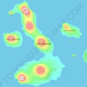
Name: Isla Isabela topographic map, elevation, terrain.
Location: Isla Isabela, Galápagos, Ecuador (-1.05406 -91.59387 0.16428 -90.78088)
Average elevation: 96 m
Minimum elevation: -1 m
Maximum elevation: 1,683 m
Make a donation
Other topographic maps
Click on a map to view its topography, its elevation and its terrain.
Isla Plaza Sur
Ecuador > Galápagos > Cantón Santa Cruz
South Plaza (Spanish: Isla Plaza Sur) is a small island off the east coast of Santa Cruz in the Galápagos Islands. It has an area of 0.13 km2 and a maximum altitude of 23 metres.
Average elevation: 5 m