
Thank you for supporting this site ❤️
Make a donation
Make a donation
Nyimba topographic map
Click on the map to display elevation.
Thank you for supporting this site ❤️
Make a donation
Make a donation
About this map
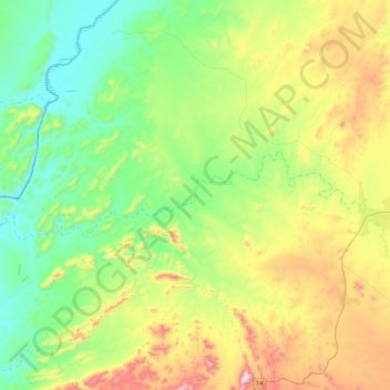
Name: Nyimba topographic map, elevation, terrain.
Location: Nyimba, Nyimba District, Eastern Province, Zambia (-14.58668 30.39193 -14.49215 30.82016)
Average elevation: 662 m
Minimum elevation: 402 m
Maximum elevation: 1,223 m
Thank you for supporting this site ❤️
Make a donation
Make a donation
Other topographic maps
Click on a map to view its topography, its elevation and its terrain.
Chadiza
Chadiza is a town in the Eastern Province of Zambia. Its headquarters are located in Chadiza District. It lies 35 km south of the Great East Road and about 80 km south-south-west of Chipata, on a plateau (elevation 1050 m) studded by isolated rocky hills, between the middle Luangwa valley and the Zambezi. It…
Average elevation: 1,055 m