
Thank you for supporting this site ❤️
Make a donation
Make a donation
Kabwe District topographic map
Click on the map to display elevation.
Thank you for supporting this site ❤️
Make a donation
Make a donation
About this map
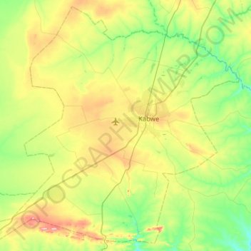
Name: Kabwe District topographic map, elevation, terrain.
Location: Kabwe District, Central Province, Zambia (-14.69612 28.11475 -14.21902 28.63321)
Average elevation: 1,165 m
Minimum elevation: 1,094 m
Maximum elevation: 1,316 m
Thank you for supporting this site ❤️
Make a donation
Make a donation
Other topographic maps
Click on a map to view its topography, its elevation and its terrain.