
Pirin topographic map
Interactive map
Click on the map to display elevation.
About this map
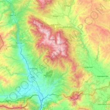
Name: Pirin topographic map, elevation, terrain.
Location: Pirin, Bulgaria (41.36419 23.11097 41.93042 24.01758)
Average elevation: 968 m
Minimum elevation: 58 m
Maximum elevation: 2,908 m
The Pirin Mountains (Bulgarian: Пирин [ˈpirin]) are a mountain range in southwestern Bulgaria, with Vihren at an altitude of 2,914 m being the highest peak.
Other topographic maps
Click on a map to view its topography, its elevation and its terrain.
Golemo Buchino
Golemo Buchino, Pernik, 2304, Bulgaria
Average elevation: 837 m
Banski Suhodol Glacier
Banski Suhodol Glacier, За Гредаро, Kresna, Blagoevgrad, Bulgaria
Average elevation: 2,493 m
Chavdartsi
Chavdartsi, Elena, Veliko Tarnovo, Bulgaria
Average elevation: 496 m
Rhodope Mountains
Rhodope Mountains, Smolyan, Smolian, Smolyan, 4700, Bulgaria
Average elevation: 1,979 m