
Siavonga District topographic map
Interactive map
Click on the map to display elevation.
About this map
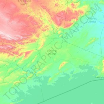
Name: Siavonga District topographic map, elevation, terrain.
Location: Siavonga District, Southern Province, Zambia (-16.69275 28.12274 -16.05145 28.82618)
Average elevation: 697 m
Minimum elevation: 407 m
Maximum elevation: 1,538 m
Other topographic maps
Click on a map to view its topography, its elevation and its terrain.
Choma
Choma lies on the Lusaka–Livingstone Road, approximately 292 kilometres (181 mi) south-west of Lusaka, the national capital and largest city in Zambia. This is approximately 194 kilometres (121 mi), by road, northeast of Livingstone, the largest city in Zambia's Southern Province. The geographical…
Average elevation: 1,310 m