
Make a donation
Luangwa topographic map
Click on the map to display elevation.
Make a donation
Luangwa
Note: distances stated are approximate straight-line distances from source. The Luangwa rises in the Lilonda and Mafinga Hills in north-east Zambia at an elevation of around 1,500 metres (4,900 ft), near the border with Tanzania and Malawi, and flows in a southwesterly direction through a broad valley. About 150 kilometres (93 mi) from its source it has dropped to an elevation of about 690 metres (2,260 ft) and becomes a meandering river with a floodplain several kilometres wide. Over the next 300 kilometres (190 mi) the meanders increase, with many oxbow lakes and abandoned meanders. Near Mfuwe, the river's elevation has dropped to about 520 metres (1,710 ft), the floodplain is about 10 kilometres (6.2 mi) wide and the valley reaches about 100 kilometres (62 mi) wide, with a north-west escarpment (Muchinga Escarpment) about 700 metres (2,300 ft) high, and a south-western escarpment about 450 metres (1,480 ft) high. In the dry season some sections, especially in the upper reaches, dry out completely, leaving isolated pools.
Make a donation
About this map
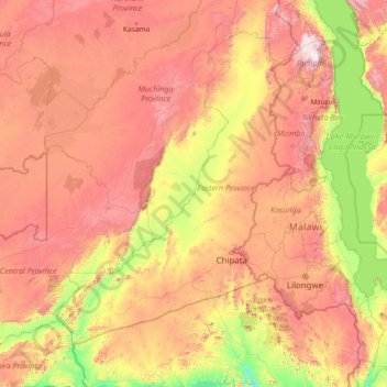
Name: Luangwa topographic map, elevation, terrain.
Location: Luangwa, Zambia (-15.62092 30.19639 -9.85132 33.32065)
Average elevation: 996 m
Minimum elevation: 288 m
Maximum elevation: 2,522 m
Make a donation
Other topographic maps
Click on a map to view its topography, its elevation and its terrain.
Lusaka
Lusaka (/luːˈsɑːkə/; loo-SAH-kə) is the capital and largest city of Zambia. It is one of the fastest-developing cities in southern Africa. Lusaka is in the southern part of the central plateau at an elevation of about 1,279 metres (4,196 ft). As of 2019, the city's population was about 3.3 million, while…
Average elevation: 1,227 m
Make a donation
Nakonde
This is approximately 350 kilometres (217 mi), by road, north of Mpika, the largest city in the province. The geographical coordinates of the town are: 09°19'38.0"S, 32°45'30.0"E (Latitude:-9.327222; Longitude:32.758333). The average elevation of Nakonde is about 1,306 metres (4,285 ft), above sea level.…
Average elevation: 1,613 m
Make a donation
Mbala
The town is at the edge of the plateau covering most of Zambia, at an elevation of 1670 m, about 900 m higher than Lake Tanganyika, which comes within 22 km (straight-line distance). The escarpment above the lake is the end of the Albertine Rift, the western branch of the East Africa Rift, and the Mbala area…
Average elevation: 1,632 m
Solwezi
Zambia > North-Western Province
Solwezi is located on the Chingola–Solwezi–Mwinilunga Road (T5 Road of Zambia), approximately 177 kilometres (110 mi) north-west of Chingola and approximately 275 kilometres (171 mi) south-east of Mwinilunga, in the extreme northwest of the country. The geographical coordinates of the city…
Average elevation: 1,352 m
Make a donation
Chinsali
The geographical coordinates of Chinsali Town are 10°33'08.0"S, 32°04'09.0"E (Latitude:-10.552222; Longitude:32.069167). The town is nestled at an average elevation of 1,383 metres (4,537 ft) above mean sea level.
Average elevation: 1,294 m
Make a donation
Make a donation
Katete
Katete is a medium-sized town in the Eastern Province of Zambia, and is headquarters of Katete District. The town is at the foot of rocky hills which lie to its east, including Mpangwe Hill and Kangarema Hill, which rise to 1600 m. The hills are surrounded by cultivated fields. Katete lies on the Great East…
Average elevation: 1,069 m
Make a donation
Lusaka
Lusaka (/luːˈsɑːkə/ loo-SAH-kə) is the capital and largest city of Zambia. It is one of the fastest-developing cities in southern Africa. Lusaka is in the southern part of the central plateau at an elevation of about 1,279 metres (4,196 ft). As of 2019, the city's population was about 3.3 million, while…
Average elevation: 1,227 m
Make a donation
Make a donation
Make a donation
Chipata
Chipata is located on the Great East Road, approximately 570 kilometres (354 mi) east of Lusaka, the capital city of Zambia. This is about 150 kilometres (93 mi) west of Lilongwe, the capital city of Malawi. The geographical coordinates of Chipata are 13°38′43.0″S, 32°38′47.0″E. The average elevation…
Average elevation: 1,133 m
Make a donation
Make a donation
Mwinilunga
Zambia > North-Western Province
Mwinilunga sits in the extreme north-western corner of the country, close to the international borders with Angola and the Democratic Republic of the Congo. The geographical coordinates of Mwinilunga, Zambia are:11°43'02.0"S, 24°25'44.0"E (Latitude:-11.717222; Longitude:24.428889). The average elevation of…
Average elevation: 1,345 m
Make a donation
Make a donation
Solwezi
Zambia > North-Western Province
Solwezi is located on the Chingola–Solwezi–Mwinilunga Road (T5 Road of Zambia), approximately 177 kilometres (110 mi) north-west of Chingola and approximately 275 kilometres (171 mi) south-east of Mwinilunga, in the extreme northwest of the country. The geographical coordinates of the city…
Average elevation: 1,352 m
Make a donation
Make a donation
Lusaka
Lusaka (/luːˈsɑːkə/ loo-SAH-kə) is the capital and largest city of Zambia. It is one of the fastest-developing cities in southern Africa. Lusaka is in the southern part of the central plateau at an elevation of about 1,279 metres (4,196 ft). As of 2019, the city's population was about 3.3 million, while…
Average elevation: 1,227 m
Make a donation
Chinsali
The geographical coordinates of Chinsali Town are 10°33'08.0"S, 32°04'09.0"E (Latitude:-10.552222; Longitude:32.069167). The town is nestled at an average elevation of 1,383 metres (4,537 ft) above mean sea level.
Average elevation: 1,294 m
Make a donation
Mporokoso
Mporokoso (also spelled and pronounced 'Mpolokoso' and 'Mumpolokoso') is a town in the Northern Province of Zambia, lying at an elevation of nearly 1500 m on the flat plateau about 75 km south east of Lake Mweru Wantipa and 100 km south-west of Lake Tanganyika. It is named for Chief Mporokoso (also spelled…
Average elevation: 1,439 m
Lusaka
Lusaka (/luːˈsɑːkə/ loo-SAH-kə) is the capital and largest city of Zambia. It is one of the fastest-developing cities in southern Africa. Lusaka is in the southern part of the central plateau at an elevation of about 1,279 metres (4,196 ft). As of 2019, the city's population was about 3.3 million, while…
Average elevation: 1,227 m
Make a donation
Solwezi
Zambia > North-Western Province
Solwezi is located on the Chingola–Solwezi–Mwinilunga Road (T5 Road of Zambia), approximately 177 kilometres (110 mi) north-west of Chingola and approximately 275 kilometres (171 mi) south-east of Mwinilunga, in the extreme northwest of the country. The geographical coordinates of the city…
Average elevation: 1,352 m
Mporokoso
Mporokoso (also spelled and pronounced 'Mpolokoso' and 'Mumpolokoso') is a town in the Northern Province of Zambia, lying at an elevation of nearly 1500 m on the flat plateau about 75 km south east of Lake Mweru Wantipa and 100 km south-west of Lake Tanganyika. It is named for Chief Mporokoso (also spelled…
Average elevation: 1,439 m
Make a donation
Lusaka
Lusaka (/luːˈsɑːkə/; loo-SAH-kə) is the capital and largest city of Zambia. It is one of the fastest-developing cities in southern Africa. Lusaka is in the southern part of the central plateau at an elevation of about 1,279 metres (4,196 ft). As of 2019, the city's population was about 3.3 million, while…
Average elevation: 1,227 m
Make a donation
Mbala
The town is at the edge of the plateau covering most of Zambia, at an elevation of 1670 m, about 900 m higher than Lake Tanganyika, which comes within 22 km (straight-line distance). The escarpment above the lake is the end of the Albertine Rift, the western branch of the East Africa Rift, and the Mbala area…
Average elevation: 1,632 m