
Thank you for supporting this site ❤️
Make a donation
Make a donation
West Sumatra topographic map
Click on the map to display elevation.
Thank you for supporting this site ❤️
Make a donation
Make a donation
About this map
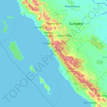
Name: West Sumatra topographic map, elevation, terrain.
Location: West Sumatra, Sumatra, Indonesia (-3.88396 98.23640 0.90672 101.89288)
Average elevation: 165 m
Minimum elevation: -3 m
Maximum elevation: 3,306 m
Thank you for supporting this site ❤️
Make a donation
Make a donation
Other topographic maps
Click on a map to view its topography, its elevation and its terrain.