
Make a donation
Indonesia topographic map
Click on the map to display elevation.
Make a donation
Indonesia
Indonesia's topography is as varied as its expansive archipelago, marked by rugged mountain ranges, volcanic activity, and vast lowland plains. The majority of its major islands are mountainous, with some of the highest peaks rising above 16,000 feet (4,877 meters), such as Puncak Jaya in Papua. These mountains, part of the Pacific Ring of Fire, are often volcanic, contributing to frequent eruptions and seismic activity. The western islands, like Sumatra and Java, are particularly mountainous with steep, densely forested landscapes, while the eastern regions, such as Papua, feature towering ranges and glacial peaks. Between these highlands, Indonesia's lowlands primarily consist of coastal plains and river valleys, which are especially prominent on islands like Borneo and Sumatra. This diversity in terrain—ranging from volcanic peaks to deep sea trenches—creates a complex and dynamic landscape, fostering a unique biodiversity and a range of ecosystems across the country.
Make a donation
About this map
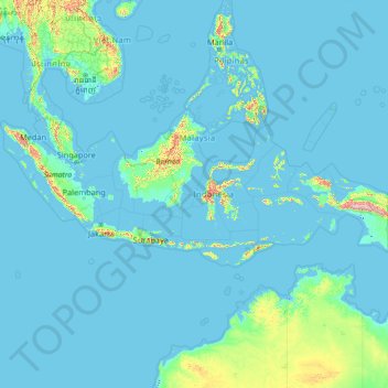
Name: Indonesia topographic map, elevation, terrain.
Location: Indonesia (-11.20857 94.77171 6.27445 141.01944)
Average elevation: 81 m
Minimum elevation: -3 m
Maximum elevation: 4,198 m
Make a donation
Other topographic maps
Click on a map to view its topography, its elevation and its terrain.
Vienna
Vienna is located in northeastern Austria, at the easternmost extension of the Alps in the Vienna Basin. The earliest settlement, at the location of today's inner city, was south of the meandering Danube while the city now spans both sides of the river. Elevation ranges from 151 to 542 m (495 to 1,778 ft). The…
Average elevation: 231 m
Chinsali
The geographical coordinates of Chinsali Town are 10°33'08.0"S, 32°04'09.0"E (Latitude:-10.552222; Longitude:32.069167). The town is nestled at an average elevation of 1,383 metres (4,537 ft) above mean sea level.
Average elevation: 1,294 m
Make a donation
Mbala
The town is at the edge of the plateau covering most of Zambia, at an elevation of 1670 m, about 900 m higher than Lake Tanganyika, which comes within 22 km (straight-line distance). The escarpment above the lake is the end of the Albertine Rift, the western branch of the East Africa Rift, and the Mbala area…
Average elevation: 1,632 m
Solwezi
Zambia > North-Western Province
Solwezi is located on the Chingola–Solwezi–Mwinilunga Road (T5 Road of Zambia), approximately 177 kilometres (110 mi) north-west of Chingola and approximately 275 kilometres (171 mi) south-east of Mwinilunga, in the extreme northwest of the country. The geographical coordinates of the city…
Average elevation: 1,352 m
Make a donation
Make a donation
Nakonde
This is approximately 350 kilometres (217 mi), by road, north of Mpika, the largest city in the province. The geographical coordinates of the town are: 09°19'38.0"S, 32°45'30.0"E (Latitude:-9.327222; Longitude:32.758333). The average elevation of Nakonde is about 1,306 metres (4,285 ft), above sea level.…
Average elevation: 1,613 m
Make a donation
Make a donation
Choma
Choma lies on the Lusaka–Livingstone Road, approximately 292 kilometres (181 mi) south-west of Lusaka, the national capital and largest city in Zambia. This is approximately 194 kilometres (121 mi), by road, northeast of Livingstone, the largest city in Zambia's Southern Province. The geographical…
Average elevation: 1,310 m
Make a donation
Make a donation
Chadiza
Chadiza is a town in the Eastern Province of Zambia. Its headquarters are located in Chadiza District. It lies 35 km south of the Great East Road and about 80 km south-south-west of Chipata, on a plateau (elevation 1050 m) studded by isolated rocky hills, between the middle Luangwa valley and the Zambezi. It…
Average elevation: 1,055 m
Make a donation
Ma'uŋa Te Hoŋa (O Koro)
Chile > Valparaiso Region > Easter Island Province > Easter Island
Average elevation: 255 m
Make a donation
Gjeravica
Gjeravica (Albanian indefinite form: Gjeravicë; Serbian: Ђеравица / Đeravica) is a mountain peak in Kosovo. It also is the second-highest mountain peak in the Accursed Mountains range and the Dinaric Alps range, after Jezercë. It has an elevation of 2,656 m (8,714 ft) above sea level. Gjeravica is…
Average elevation: 2,214 m
Swat
Pakistan > Khyber Pakhtunkhwa > Charsadda District > بانڈہ سیداں > بِجلۍ کورونه
Average elevation: 370 m
Make a donation
Islamabad
Pakistan > Islamabad Capital Territory
Islamabad's micro-climate is regulated by three artificial reservoirs: Rawal, Simli, and Khanpur Dam. The latter is located on the Haro River near the town of Khanpur, about 40 kilometres (25 mi) from Islamabad. Simli Dam is 30 kilometres (19 mi) north of Islamabad. 220 acres (89 ha) of the city consists of…
Average elevation: 666 m
Make a donation
Make a donation
Philippine Sea
Average elevation: 0 m
Make a donation
Make a donation
Kotli
India > Himachal Pradesh > Kotli
Kotli Tungal (Kotli) is a small town in Himachal Pradesh, in northern India located along national highway 70 (updated 003) which connects Jalandhar (in Punjab) to Mandi. It is 22 km (14 mi) from the town of Mandi, Kotli is a Sub Division and Tehsil (Sub District) of Mandi District. Kotli and the surrounding…
Average elevation: 1,194 m
Make a donation
Make a donation
Make a donation
Naqamte
Nekemte, also spelled as Neqemte (Oromo: Naqamtee, Amharic: ነቀምት), is a market city and separate woreda in western Ethiopia. Located in the East Welega Zone of the Oromia Region, Nekemte has a latitude and longitude of 9°5′N 36°33′E / 9.083°N 36.550°E / 9.083; 36.550 and an elevation of 2,088 meters.
Average elevation: 1,909 m
Make a donation
Make a donation
Make a donation
Make a donation
Abuja
Nigeria > Federal Capital Territory > Municipal Area Council
The elevation is 360 metres (1,180 ft).
Average elevation: 508 m
Make a donation
Athens
Greece > Attica > Regional Unit of Central Athens
The southern section of the Athens metropolitan area (i.e., Elliniko, Athens Riviera) lies in the transitional zone between Mediterranean (Csa) and hot semi-arid climate (BSh), with its port-city of Piraeus being the most extreme example, receiving just 331.9 millimetres (13.07 in) per year. The areas to the…
Average elevation: 168 m
Make a donation
Make a donation
Culiacán
Culiacán is located in the central region of the State of Sinaloa, forming part of the Northwest of Mexico. The coordinates that correspond to it are 24 ° 48'15 "N (latitude) by 107 ° 25'52" W (West), with an altitude of 54 meters above sea level.
Average elevation: 85 m
Make a donation